INTRODUCTION
The purpose of this section is to describe the community input process coordinated through the Citizens Advisory Boards (CABs) and present demographic data for each of the five Regional Services areas. The community input process makes it easier for residents to focus on regional issues in the proposed Capital Improvements Program (CIP). The preparation of this section completes several months of consulting the citizens of the various communities within Montgomery County.
The consultation process included the following steps:
- During the preparation of the recommended CIP, the Citizens Advisory Boards sponsored forums in all five of the Regional Services areas: Bethesda-Chevy Chase, East County, Mid-County, Silver Spring, and Upcounty. In addition, a Countywide virtual forum was held. These forums provided residents with an opportunity to express their views on the future of the CIP in their area and to indicate their priorities for the CIP. Department and agency representatives were present at the forums.
- The Citizens Advisory Boards provided their recommendations to the County Executive.
- The County Executive considered each recommendation in making decisions on projects to be included in this recommended CIP.
The Public Input section also includes the following information:
- A geographic and demographic description of each of the Regional Services areas.
- Information about the Open Data Budget Publication.
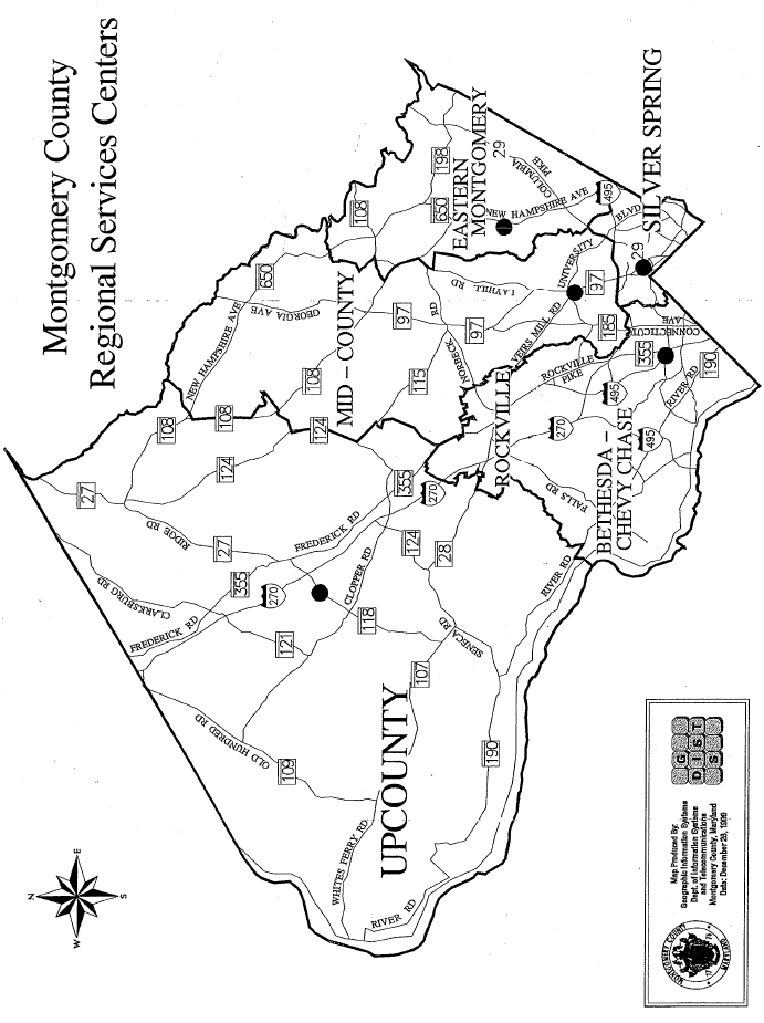
- A map of the County Regional Services areas showing the service areas by communities and vicinities.
OPEN BUDGET
Montgomery County, Maryland offers a comprehensive Open Data Budget Publication that takes the very complex and detailed data found in the traditional budget publication and transforms it into an intuitive, accessible, and shareable format making it easier for the public to be informed about approved and recommended capital projects. Features included are:
- Interactive charts, tables, maps, and videos
- A custom Google search engine
- Archiving previous years' data/content
- Unlimited sharing/discovery of data, tables, and visualizations
- Mobility (works on smartphones, tablets, and desktops)
- American with Disabilities Act (ADA) compliance
- Instantly translatable into 90+ languages
REGIONAL SERVICE AREA DESCRIPTIONS
The Regional Services areas were established by grouping together the existing land use master planning areas to form contiguous areas broadly similar in growth and development characteristics and with similar capital planning issues. The division by service area is intended mainly for the convenience of residents in understanding capital budget issues in their areas. Established planning documents, such as the Growth Policy and master plans, will continue to be presented by policy area or planning area, as appropriate. The charts on the following pages display percentages of County population by service area from 2020 to projected 2050 and household population and the number of household data, as well as growth rates, by service area for the same period.
An index of CIP projects by planning area is contained at the back of the CIP publication.
Bethesda-Chevy Chase
The Bethesda-Chevy Chase service area consists of the older, more developed areas in the southwestern part of Montgomery County, closest to the District of Columbia. It includes the communities and vicinities of Potomac-Cabin John, North Bethesda-Garrett Park, City of Rockville, and Bethesda-Chevy Chase. Bethesda-Chevy Chase is the second largest service area in population size, containing in 2020 approximately 24.8 percent of the County's total population. Growth in all service areas is tracked by total growth in household population and number of households. From 2020 to 2035 the area is expected to grow by 15.9 percent in household population. The growth of household numbers is slightly higher, at about 21.1 percent. From 2035 to 2050, area population growth is expected to be 14.3 percent, with household growth for this same period expected to be 14.5 percent.
East County
The East County service area consists of the easternmost sections of the County closest to Prince George's County. It includes the communities and vicinities of the Patuxent Watershed, Cloverly-Norwood, Colesville-White Oak, and Fairland-Beltsville. East County is the smallest service area in population size, containing 9.9 percent of the County population in 2020. From 2020 to 2035, the area is expected to increase 4.4 percent in household population. There will be growth in the number of households at about 6.7 percent. From 2035 to 2050, area household population growth is expected to increase by 6.7 percent while household growth will increase by 7.6 percent.
Mid-County
The Mid-County service area is centered along both sides of Georgia Avenue. It covers the communities and vicinities of Patuxent Watershed, Upper Rock Creek, Olney, Aspen Hill, Kensington-Wheaton, and Kemp Mill-Four Corners. Mid-County is the third largest service area in population, containing 21.3 percent of the County population in 2020. From 2020 to 2035, 4.6 percent growth is expected in household population and the number of households is expected to grow 6.6 percent over the same period. From 2035 to 2050, area population growth of 6.9 percent is expected while approximately 7.3 percent growth is expected in the number of households. A small portion of this area remains parkland and agricultural preserve, limiting future growth opportunities.
Silver Spring
The Silver Spring service area includes the communities and vicinities of Kemp Mill-Four Corners, Silver Spring, and Takoma Park. It covers the southeastern corner of the County bordering the District of Columbia and Prince George's County. Silver Spring is the second smallest service area in population size, containing 10.4 percent of the County population in 2020. From 2020 to 2035, the area is expected to grow 7.9 percent in household population. The growth in households will be faster, at 11.3 percent. From 2035 to 2050, area population growth of approximately 9.6 percent is expected while 9.7 percent growth is expected in the number of households.
Upcounty
The Upcounty service area consists of growing areas of the County along the upper I-270 corridor, encompassing the largest geographical area which consists of the northern and western parts of Montgomery County. This area includes the communities and vicinities of Bennett and Little Bennett Watershed, Damascus, Barnesville, Dickerson, Clarksburg, Goshen, Woodfield, Cedar Grove, Martinsburg, Poolesville, Lower Seneca Basin, Germantown, Gaithersburg, Upper Rock Creek, Darnestown, and Travilah. Not only has this area experienced swift growth in the number of residents, it is also the area with the greatest concentration of new research and development, manufacturing, and commercial employment. Upcounty is the largest area in population size and comprises 33.5 percent of the entire County population in 2020. From 2020 to 2035, the area is expected to grow 7.4 percent in household population. The household growth rate is expected to be faster, at 10.3 percent. From 2035 to 2050, area population growth is projected at 4.9 percent while growth in the number of households is projected at 5.7 percent.
Countywide Projects
Numerous Countywide projects are included in the CIP and may include improvements located in one or more of the service areas. For more information on improvements included in Countywide projects, please refer to the individual project description forms.
MONTGOMERY COUNTY POPULATION/HOUSEHOLDS BY REGIONAL SERVICES AREA, 2020 - 2050
Growth and Projections for Regional Services Areas
Household Population and Number of Households: 2020, 2025, 2030, 2035, 2040, 2045, and 2050

*Totals may not sum due to rounding
Regional Services Area and Corresponding Planning Area

Notes: Planning areas of Kemp Mill-Four Corners, Patuxent Watershed, and Upper Creek Watershed are split between two service areas.
Planning Areas and Corresponding Service Areas
| Planning Area Name | Service Area |
|---|
| Aspen Hill and Vicinity | Mid-County |
| Bennett and Little Bennett Watershed | Upcounty |
| Bethesda-Chevy Chase and Vicinity | Bethesda |
| Bi-County | All |
| Clarksburg and Vicinity | Upcounty |
| Cloverly-Norwood | East County |
| Colesville-White Oak and Vicinity | East County |
| Countywide | All |
| Damascus and Vicinity | Upcounty |
| Darnestown and Vicinity | Upcounty |
| Fairland-Beltsville and Vicinity | East County |
| Gaithersburg and Vicinity | Upcounty |
| Germantown and Vicinity | Upcounty |
| Goshen-Woodfield-Cedar Grove and Vicinity | Upcounty |
| Kemp Mill-Four Corners and Vicinity | Mid-County and Silver Spring |
| Kensington-Wheaton | Mid-County |
| Little Monocacy Basin Dickerson-Barnesville | Upcounty |
| Lower Seneca Basin | Upcounty |
| Martinsburg and Vicinity | Upcounty |
| North Bethesda-Garrett Park | Bethesda |
| Olney and Vicinity | Mid-County |
| Patuxent Watershed Conservation Area | East County and Mid-County |
| Poolesville and Vicinity | Upcounty |
| Potomac-Cabin John and Vicinity | Bethesda |
| Rockville | Bethesda |
| Silver Spring and Vicinity | Silver Spring |
| Takoma Park | Silver Spring |
| Travilah and Vicinity | Upcounty |
| Upper Rock Creek Watershed | Mid-County and Upcounty |